Remote Sensing Satellite Market Size
| Study Period | 2018 - 2028 |
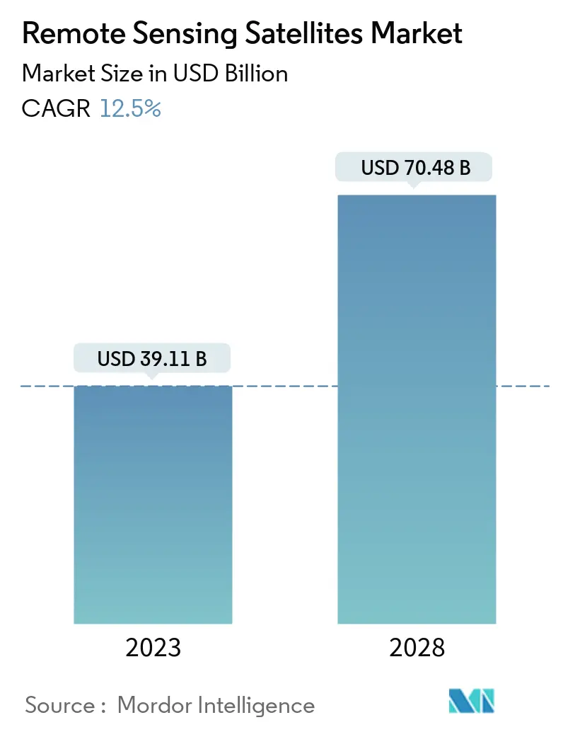
| Market Size (2023) | USD 39.11 Billion |
| Market Size (2028) | USD 70.48 Billion |
| CAGR (2023 - 2028) | 12.50 % |
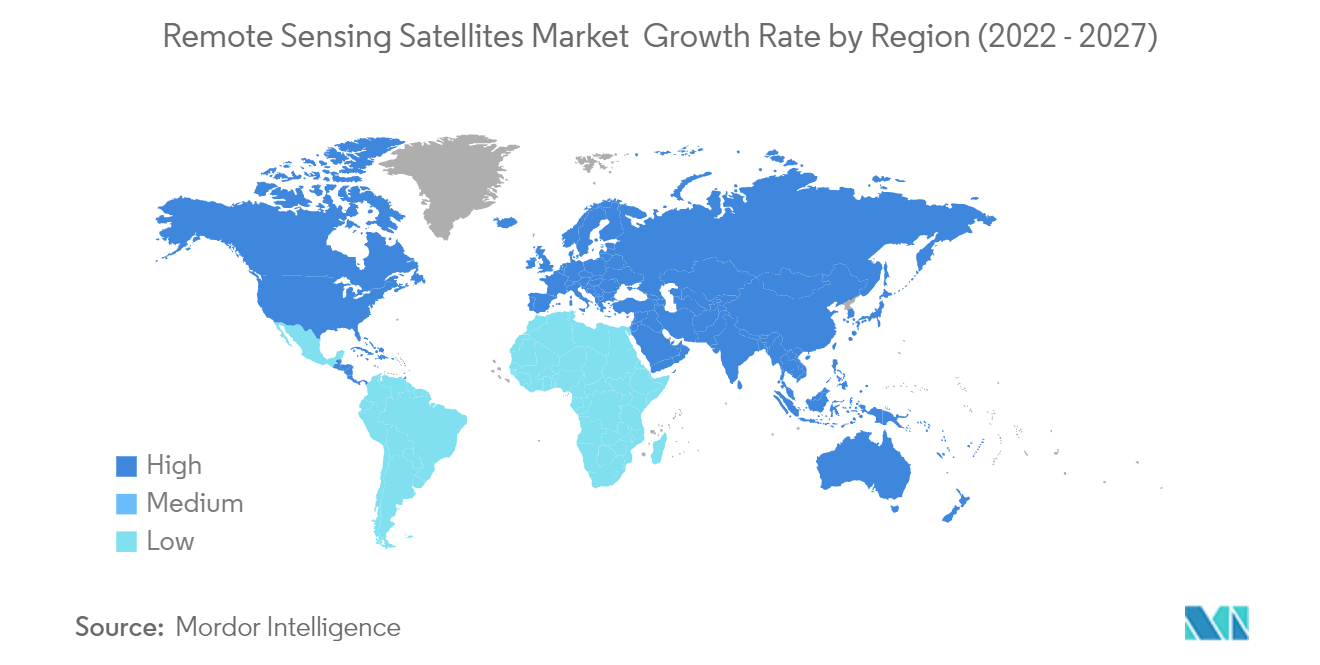
| Fastest Growing Market | Asia-Pacific |
| Largest Market | North America |
Major Players
*Disclaimer: Major Players sorted in no particular order |
Need a report that reflects how COVID-19 has impacted this market and its growth?
Remote Sensing Satellite Market Analysis
The Remote Sensing Satellites Market size is expected to grow from USD 39.11 billion in 2023 to USD 70.48 billion by 2028, at a CAGR of 12.50% during the forecast period (2023-2028).
Though the COVID-19 pandemic resulted in shockwaves for specific industries, the satellite manufacturing industry was insulated to a greater extent from the effects of the pandemic. This was due to the satellite industry's high dependence on government contracts, where up to 70% of the market in some areas such as Earth Observation. In addition, the highly reliable and survivable nature of satellite communications services which are essential for disaster communications and backup services insulated the industry from some of the more severe impacts of the global pandemic. However, the postponement of launch schedules, the stoppage of many satellite production lines, and the drying up of private financing have disorganized emerging operators, exposing them to a cycle of financial distress.
The technology of remote sensing satellites has witnessed advancements on three fronts: environmental analysis of the atmosphere, ocean, and land for military purposes, sensors that can convert electromagnetic spectrum to electronic signals, and aircraft to satellite platforms.
The concept of remote sensing satellites originated in 1999 with the IKONOS satellite, which was the world's first remote sensing satellite capable of providing high-resolution images. Quickbird, WorldView-1 satellite, GeoEye-1, and WorldView-2 satellites were launched in October 2001, September 2007, September 2008, and October 2009, respectively, with improved resolutions. Remote sensing satellite technology has gained many advancements in the past few years, with various companies developing advanced satellites with artificial intelligence. The remote gathering and obtaining of spatial information is one of the most powerful means to understand and respond efficiently to urgent humanitarian and environmental threats. Such processes were extremely difficult in the past owing to limitations in terms of proper data.
With the continuous improvements in remote sensing technologies and methods in recent years, great strides have been made by countries globally in terms of remote sensing as well as image processing. Satellite, UAV, airborne and terrestrial imaging are witnessing continuous improvements in data variety, volume, and quality. As of the present scenario, the combination of various data sources and faster analysis have led to remote sensing satellites gaining more and more significance for carrying out a broad range of applications.
Remote Sensing Satellite Market Trends
This section covers the major market trends shaping the Remote Sensing Satellites Market according to our research experts:
Earth Observation Segment is Expected to Lead the Market
The regional conflicts, rapid deployment, and flexible response impose a heavy burden on military commanders, their staff, and supporting system to keep abreast with the situation on the ground about enemy activities. Spatial data is crucial for informed decision-making in the defense sector, and it assists in diverse strategic activities such as battlefield simulation, mission briefing, and communications planning, logistics management, and command control. Remotely sensed satellite images and data include spectral, spatial, and temporal resolutions. Geographic Information Systems (GIS) also allows military land and facilities managers to reduce base operation and maintenance costs, improve mission effectiveness, provide rapid modeling capabilities for analyzing alternative strategies, improve communication, and store institutional knowledge.
Advanced nations, such as the US, China, and Russia have reorganized their militaries to adopt space-based technologies such as space-based intelligence, surveillance, and reconnaissance (ISR) capabilities. Several nations are making significant investments to develop space-based satellite constellations that would enable them to command and control their forces worldwide and also with enhanced situational awareness, enabling them to monitor, track, and target hostile forces.
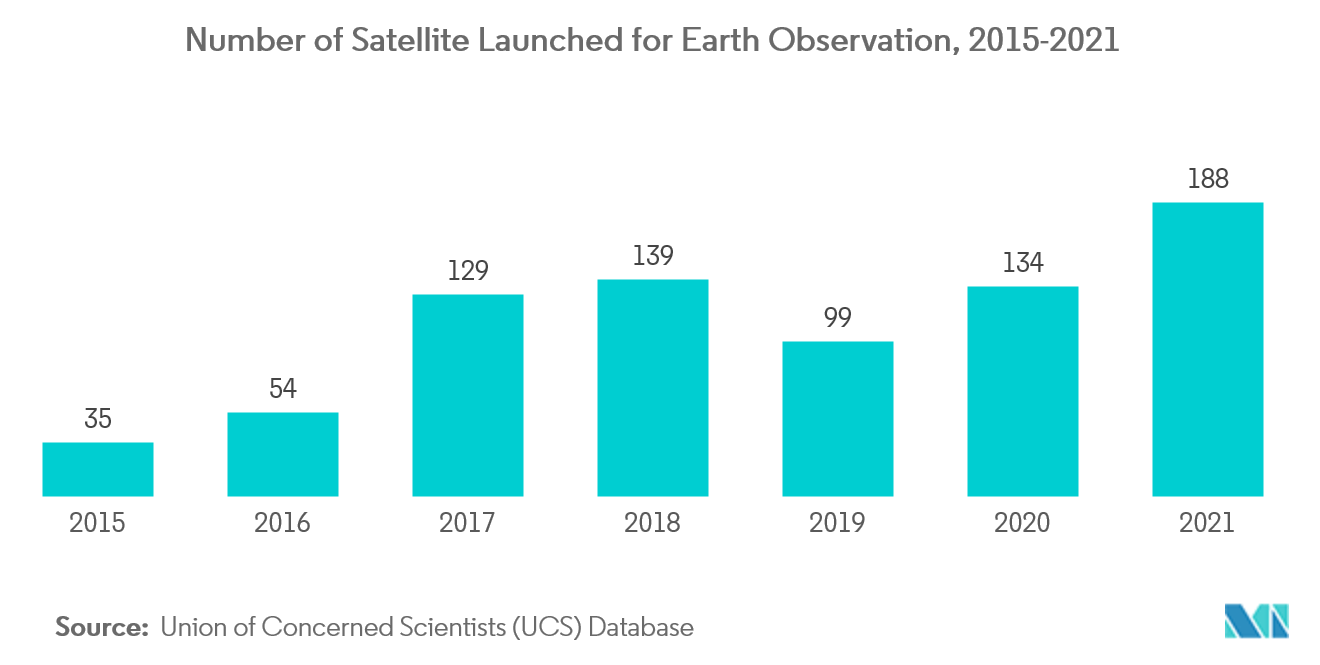
Earth Observation satellites are used for Earth observation from orbit. The satellites are also used to monitor spy satellites and other similar satellites for non-military purposes such as environmental monitoring.
With an increased budget and rising spending capabilities, multiple new projects have been announced to monitor the earth better. For instance,
In January 2022, NASA announced the planned launch of 4 Earth science missions in 2022. These missions are anticipated to provide scientists with new data on core climate systems and processes, including extreme storms, surface water and oceans, and atmospheric dust.
Similarly, the Indian Space Research Organization (ISRO), in August 2022, launched a new Earth Observation Satellite (EOS) to be used for multiple purposes across the users in the country. This satellite was also preceded by the country’s EOS 4 in February 2022. These satellites were named ‘eye in the sky’, showcasing their observational capabilities.
Technological companies across the world have been investing in improving the existing earth monitoring capabilities to provide better services to the users on the surface. Owing to this, the need for better observation satellites is expected to grow during the coming years. For instance,
In October 2021, Satellite data provider Planet announced its plans to launch a new fleet of orbiting satellites. The company already operates 200 Earth observation satellites from space and is aiming to launch a new fleet of satellites called Pelican by 2023. This new fleet of satellites will be used for mapping services across the world. Multiple use cases, along with a broad range of industries that find utilization using earth observation satellites, are expected to lead the market during the forecast period.
North America is Expected to Dominate the Market During the Forecast Period
The United States has become a global power in space technology due to the technological advancements made by the National Aeronautics and Space Administration (NASA). The increasing utilization of various kinds of satellites for multiple purposes has generated significant demand across the United States and, consequently, across the world. The country’s military is a global firepower and generates significant market growth opportunities across various segments in the remote sensing satellites market. Owing to the demand for various networks, navigation, and entertainment purposes, various satellites are being launched across the country, increasing the market demand. For instance,
In August 2022, Northrop Grumman, in partnership with Lockheed Martin Corporation, designed and built the mission payload of the Space Based Infrared System Geosynchronous Earth Orbit (SBIRS GEO)-6 satellite. This satellite will be used by the United States military for mapping and surveillance purposes, creating fantastic future opportunities. Owing to this, the United States has been launching new communication and media satellites. For instance,
In October 2022, SpaceX’s Falcon 9 Heavy launched 2 new satellites, Galaxy 33 and Galaxy 34 of Intelsat. These new satellites equipped with new technology will provide Intelsat Media customers in the region with high-performance media distribution capabilities.
Canada has been investing significantly in its remote sensing satellite capabilities. The market’s defense segment in Canada has witnessed significant developments in terms of investments and technological advancements over the years. Further, the country’s excellent diplomatic relations and partnership with the United States have necessitated high defense investments as part of NORAD. As of 2021, StarlinkCanada and Canadian satellite communications firm Telesathave been working on low-Earth Orbit satellite constellations to offer network services by launching and operating hundreds of satellites in 2022. This will significantly increase the demand and initiate the technological advancement toward satellite network connections for commercial applications and drive a huge market growth rate in United States and Canada during the forecast period.
Remote Sensing Satellite Industry Overview
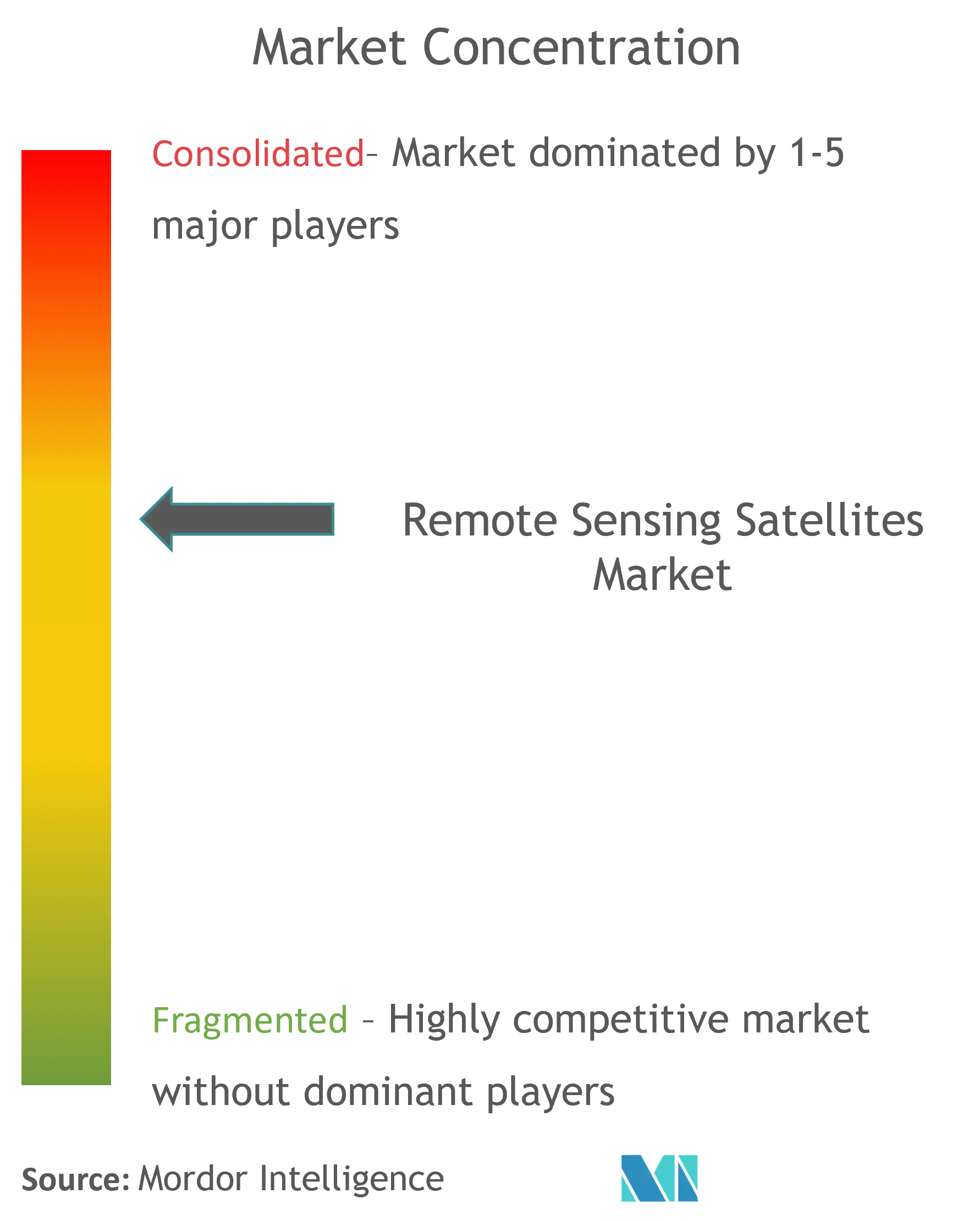
Though the remote sensing satellite market is characterized by the presence of several players, the market is dominated by only a few players, such as Lockheed Martin Corporation, Northrop Grumman Corporation, and Airbus SE, owing to their huge product offering. Since traditional satellite manufacturers are not the sole investors of the market in focus, a radical change in the market dynamics is anticipated to emerge. Hence, to retain their competitive edge, some satellite ventures have plans to manufacture space systems, payloads, or subsystems and components in-house.
Also, major technological shifts such as miniaturization, and the advent of reusable satellite launch vehicle systems would necessitate subsequent adaptation for seizing emerging market opportunities. Moreover, owing to the long R&D period associated with the satellite industry, some companies are exposed to certain risks associated with design responsibility, the development of new production tools, more capital and funding commitments, delivery schedules, and unique contractual requirements. These risks, if not resolved swiftly, can affect the financial status of the market players and expose them to revenue fluctuations.
Remote Sensing Satellite Market Leaders
Airbus SE
The Boeing Company
Northrop Grumman Corporation
Lockheed Martin Corporation
Thales Group
*Disclaimer: Major Players sorted in no particular order
Remote Sensing Satellite Market News
In October 2022, Russia has launched a navigation satellite, GLONASS-K, from Plesetsk Cosmodrome. It was launched using a Soyuz-2.1b medium-class launch vehicle. The GLONASS - K will be working as a part GLONASS radio-based satellite navigation system.
In August 2022, From Xichang Satellite Launch Center in the southwestern province of Sichuan China launched the fourth batch of the Yaogan-35 family through a Long March-2D carrier rocket to place a remote sensing satellite group in space.
Remote Sensing Satellite Market Report - Table of Contents
1. INTRODUCTION
1.1 Study Assumptions
1.2 Scope of the Study
2. RESEARCH METHODOLOGY
3. EXECUTIVE SUMMARY
4. MARKET DYNAMICS
4.1 Market Overview
4.2 Market Drivers
4.3 Market Restraints
4.4 Porter's Five Forces Analysis
4.4.1 Threat of New Entrants
4.4.2 Bargaining Power of Buyers/Consumers
4.4.3 Bargaining Power of Suppliers
4.4.4 Threat of Substitute Products
4.4.5 Intensity of Competitive Rivalry
5. MARKET SEGMENTATION (Market Size by Value - USD billion)
5.1 Application
5.1.1 Earth Observation
5.1.2 Meteorology
5.1.3 Mapping and Navigation
5.2 End-user
5.2.1 Defense
5.2.2 Commercial
5.3 Geography
5.3.1 North America
5.3.1.1 United States
5.3.1.2 Canada
5.3.2 Europe
5.3.2.1 United Kingdom
5.3.2.2 France
5.3.2.3 Germany
5.3.2.4 Russia
5.3.2.5 Rest of Europe
5.3.3 Asia-Pacific
5.3.3.1 China
5.3.3.2 India
5.3.3.3 Japan
5.3.3.4 South Korea
5.3.3.5 Rest of Asia-Pacific
5.3.4 Latin America
5.3.4.1 Brazil
5.3.4.2 Peru
5.3.4.3 Rest of Latin America
5.3.5 Middle-East and Africa
5.3.5.1 United Arab Emirates
5.3.5.2 Saudi Arabia
5.3.5.3 Iran
5.3.5.4 Rest of Middle-East and Africa
6. COMPETITIVE LANDSCAPE
6.1 Vendor Market Share
6.2 Company Profiles
6.2.1 Airbus SE
6.2.2 Ball Aerospace & Technologies Corp.
6.2.3 The Boeing Company
6.2.4 Esri
6.2.5 ImageSat International N.V.
6.2.6 Maxar Technologies Ltd.
6.2.7 Mitsubishi Electric Corporation
6.2.8 Planet Labs, Inc.
6.2.9 Satellite Imaging Corporation (SIC)
6.2.10 Thales Group
6.2.11 UrtheCast Corp.
6.2.12 Lockheed Martin Corporation
6.2.13 Northrop Grumman Corporation
7. MARKET OPPORTUNITIES AND FUTURE TRENDS
Remote Sensing Satellite Industry Segmentation
Remote sensing is a key technique used to obtain information related to the earth’s resources and environment. Remote-sensing satellites detect, and record emitted energy from the earth’s surface and are used by both commercial and military end-users to ensure data-informed decision-making based on the current and future state of the planet or a particular point of interest located on the earth’s surface.
The Remote Sensing Satellite Market is segmented based on application, end-user, and geography. By application, the market is segmented into Earth Observation, Meteorology, and Mapping and Navigation. By end-user, the market is segmented into Defense and Commercial, and by Geography into North America, Europe, Asia-Pacific, Latin America, and Middle-East and Africa.
The report also covers the market sizes and forecasts for the Remote Sensing Satellites Market across major regions. For each segment, the market sizing and forecasts have been done based on value (USD million).
| Application | |
| Earth Observation | |
| Meteorology | |
| Mapping and Navigation |
| End-user | |
| Defense | |
| Commercial |
| Geography | |||||||
| |||||||
| |||||||
| |||||||
| |||||||
|
Remote Sensing Satellite Market Research FAQs
How big is the Remote Sensing Satellites Market?
The Remote Sensing Satellites Market size is expected to reach USD 39.11 billion in 2023 and grow at a CAGR of 12.5% to reach USD 70.48 billion by 2028.
What is the current Remote Sensing Satellites Market size?
In 2023, the Remote Sensing Satellites Market size is expected to reach USD 39.11 billion.
Who are the key players in Remote Sensing Satellites Market?
Airbus SE, The Boeing Company, Northrop Grumman Corporation, Lockheed Martin Corporation and Thales Group are the major companies operating in the Remote Sensing Satellites Market.
Which is the fastest growing region in Remote Sensing Satellites Market?
Asia-Pacific is estimated to grow at the highest CAGR over the forecast period (2023-2028).
Which region has the biggest share in Remote Sensing Satellites Market?
In 2023, the North America accounts for the largest market share in the Remote Sensing Satellites Market.
Remote Sensing Satellite Industry Report
Statistics for the 2023 Remote Sensing Satellite market share, size and revenue growth rate, created by Mordor Intelligence™ Industry Reports. Remote Sensing Satellite analysis includes a market forecast outlook to 2028 and historical overview. Get a sample of this industry analysis as a free report PDF download.